


Basics
- Location:
- 20 miles east of Glenwood Springs
- Length:
- 3 miles/5 km
- Difficulty:
- Intermediate
- Time:
- 1-2 hours
- Trailhead Elevation:
- 5900 feet
- Elevation Change:
- 2600 feet
- Season:
- April - October
Description
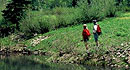
Deep Creek Trail follows Deep Creek along the bottom of a 2,500 feet narrow, steep sided cliff bordered canyon. The scenery contains outstanding and diverse features and wildlife watching, fishing, and primitive camping opportunities are good.
Site includes steep walled canyon with limestone, dolomite and sandstone cliffs. The canyon is carved 2000 feet deep into the White River Plateau. Vegetation bordering the creek in this diverse riparian zone is dominated by spruce, cottonwood and shrubs. Recreation in the area consists of hiking the trail along the creek, roadside and walk in campsites, as well as fishing, hunting and spelunking.
Use is limited to hiking; motorized vehicles are prohibited. The trail is a well defined track for the first 3 to 4 miles - it becomes diffuse in places due to narrowing of the canyon and travel on the creek bed necessary in a few places beyond 5 miles up the canyon.
Tour Companies
Vista Verde Guest Ranch - Hiking
- Near Steamboat Springs
- Hiking
- 970-879-3858
 At Vista Verde Ranch, hiking is one of the many activities you can try during your all-inclusive Colorado ranch vacation. Our guides offer a customized outdoor experience whether you want to rock climb, mountain bike, fly fish or horseback ride.
Helpful Links
Tour Companies
Vista Verde Guest Ranch - Hiking
- Near Steamboat Springs
- Hiking
- 970-879-3858
Details
Location:
Length:
Trail best defined for the first three miles - after four miles, it gets pretty indistinct
Difficulty:
Time:
Trailhead Elevation:
Elevation Change:
Season:
Useful Map(s):
Camping Info
Additional Details:
Map + Directions
Basic Directions
From I-70 at Dotsero (exit 133) drive north on the Colorado River Road (Eagle County 301) approximately 2 miles. Turn left on Coffee Pot Road and go about 2 miles to the trailhead.


